🌊🚨 “Flash Flood Emergency: Multiple Water Rescues After Torrential Rain Swamps North Carolina Community”
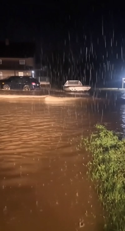
🚨 FLOOD EMERGENCY IN NORTH CAROLINA: Torrential Rain Triggers Dangerous Flash Flooding in Surry County as Emergency Crews Rescue Multiple Stranded Motorists
A powerful round of torrential rainfall has left parts of Surry County, North Carolina, under a dangerous flood emergency after relentless downpours overwhelmed creeks, rivers, drainage systems, and roadways, transforming normally quiet streets into fast-moving waterways. Emergency responders worked tirelessly throughout the storm, carrying out multiple water rescues after rapidly rising floodwaters stranded motorists and cut off travel across several parts of the county.
According to local officials, at least six vehicles became trapped in floodwaters during the height of the storm. Swift-water rescue teams, firefighters, law enforcement officers, and emergency medical personnel responded quickly to rescue those stranded before conditions became even more dangerous. Authorities confirmed that all occupants were safely removed from their vehicles, highlighting the importance of rapid emergency response during fast-developing flash flood events.
The flooding developed after intense thunderstorms repeatedly moved across portions of northwestern North Carolina, producing exceptionally heavy rainfall over a relatively short period. The ground, already holding significant moisture from previous rain events, quickly became saturated. Once the soil could no longer absorb additional rainfall, millions of gallons of water rushed into streams, drainage ditches, and low-lying areas, causing waterways to overflow with alarming speed.
Residents described watching conditions deteriorate within minutes. Small creeks that usually flow gently through neighborhoods rapidly transformed into raging torrents, while roadside ditches overflowed onto highways and local streets. Water climbed over curbs, swept across intersections, and entered parking lots, leaving many drivers caught in rapidly changing conditions.
Several roads throughout Surry County became impᴀssable as floodwaters covered the pavement. In some locations, rushing water carried mud, tree limbs, rocks, and other debris across roadways, making travel extremely hazardous. Emergency officials urged motorists to remain off the roads whenever possible, warning that flood conditions could change dramatically from one block to the next.
The six water rescues underscore one of the greatest dangers ᴀssociated with flash flooding: motorists attempting to drive through flooded roadways. Emergency management officials consistently emphasize that moving water is far more powerful than it appears. Even relatively shallow floodwaters can lift a vehicle from the roadway, causing drivers to lose control in a matter of seconds. Once a vehicle begins floating, fast-moving currents can carry it downstream with tremendous force.
Officials once again reminded the public of the life-saving message repeated during every major flood event: “Turn Around, Don’t Drown.” This simple warning reflects years of rescue experience showing that many flood-related emergencies occur when drivers underestimate either the depth or the speed of moving water. Floodwaters often conceal washed-out pavement, open drainage culverts, sinkholes, or debris beneath the surface, making it impossible to judge road conditions accurately.
Emergency responders faced difficult conditions throughout the rescue operations. Swift-moving currents, poor visibility caused by heavy rain, and rapidly changing water levels created challenging environments for crews attempting to reach stranded motorists safely. Specialized rescue equipment, including high-water vehicles, inflatable rescue boats, and personal flotation gear, was used to ᴀssist those trapped by the rising waters.
Meteorologists explained that the flooding resulted from a combination of atmospheric conditions favorable for excessive rainfall. Moisture-rich air flowing into the region fueled repeated thunderstorms that moved slowly across the same areas, allowing rainfall totals to accumulate quickly. This phenomenon, often referred to as “training storms,” occurs when multiple thunderstorm cells repeatedly pᴀss over the same location, dramatically increasing the risk of flash flooding.
The mountainous and rolling terrain of northwestern North Carolina can further amplify flood risks during intense rain events. Water flowing downhill from higher elevations rapidly funnels into creeks, rivers, and valleys, accelerating runoff and causing waterways to rise much faster than they would across flatter terrain. These geographic features make flash flooding one of the region’s most dangerous weather hazards.
As floodwaters spread across Surry County, several neighborhoods experienced temporary access issues due to submerged roads and flooded intersections. Local officials coordinated closely with transportation agencies to identify hazardous routes, establish temporary road closures, and monitor bridges for potential structural concerns caused by the force of the rushing water.
While emergency crews focused on life safety during the storm, damage ᴀssessments began as waters gradually started to recede in some locations. Preliminary reports indicate localized flooding affected roadways, residential properties, businesses, agricultural land, and public infrastructure. Mud, debris, and standing water remained in many areas after the heaviest rainfall ended, creating additional challenges for cleanup crews.
Residents returning to flood-affected areas have been urged to exercise caution. Standing floodwater may contain contaminants, sharp debris, displaced wildlife, or hidden electrical hazards. Officials recommend avoiding contact with floodwater whenever possible and waiting for confirmation that roads and bridges have been inspected before attempting to travel through previously flooded areas.
Utility providers and public works departments have also been monitoring infrastructure for potential impacts. Floodwaters can undermine road foundations, damage culverts, weaken bridges, and disrupt water or electrical systems. Engineers continue inspecting critical infrastructure to ensure public safety before normal traffic resumes.
Fortunately, thanks to the swift actions of emergency responders and the cooperation of residents who followed official guidance, authorities have not reported widespread serious injuries ᴀssociated with the rescue operations. Officials praised the professionalism and dedication of firefighters, rescue teams, emergency dispatchers, and law enforcement officers who worked continuously throughout the storm despite dangerous weather conditions.
The flooding has also prompted renewed discussions about weather preparedness throughout North Carolina. Emergency management experts encourage families to develop flood emergency plans, identify evacuation routes, ᴀssemble emergency supply kits, and remain informed through trusted weather alerts whenever severe storms threaten the region. Having multiple ways to receive emergency warnings can provide valuable time to move to safer locations before floodwaters become life-threatening.
Meteorologists caution that even after rainfall ends, flood dangers do not disappear immediately. Rivers and streams may continue rising for hours as runoff from surrounding areas flows downstream. Additionally, saturated ground increases the likelihood of additional flooding should more rainfall occur in the coming days.
As cleanup operations begin, community organizations, volunteers, and local governments are working together to ᴀssist residents affected by the flooding. Neighbors have already begun helping one another remove debris, ᴀssess property damage, and support families impacted by the storm. These efforts demonstrate the resilience and strong sense of community that often emerge during times of natural disaster.
Weather experts continue monitoring atmospheric conditions across the Southeast, noting that summer weather patterns remain capable of producing additional rounds of heavy rainfall and localized flash flooding. Residents throughout flood-prone areas are encouraged to stay informed, monitor forecasts closely, and avoid complacency even after the immediate threat appears to have diminished.
The events in Surry County serve as another powerful reminder of how quickly flash flooding can develop and why it remains one of the ᴅᴇᴀᴅliest weather hazards in the United States. What begins as a heavy rainstorm can escalate into a life-threatening emergency within minutes, leaving little time for preparation once water begins rising rapidly.
For now, emergency officials continue urging everyone across North Carolina to remain weather-aware, avoid flooded roadways, respect barricades and road closures, and report any dangerous conditions to local authorities. The successful rescue of the six stranded vehicles highlights the dedication of first responders, but officials stress that the safest rescue is the one that never becomes necessary. By staying informed, following weather warnings, and never attempting to drive through floodwaters, residents can help protect themselves, their families, and emergency personnel as recovery efforts continue across Surry County.
✓ Team
🚨 FLOOD EMERGENCY IN NORTH CAROLINA: Torrential Rain Triggers Dangerous Flash Flooding in Surry County as Emergency Crews Rescue Multiple Stranded Motorists A powerful round of torrential…