🚨 Texas Flood Emergency: Life-Threatening Flash Floods Trap Vehicles as More Dangerous Rain Approaches
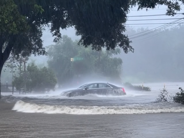
🚨 TEXAS FLOOD EMERGENCY: Boerne Overwhelmed by Dangerous Flash Flooding as Vehicles Become Trapped and Forecasters Warn of Even Worse Conditions Ahead
A rapidly escalating flood emergency is unfolding across Boerne, Texas, where relentless thunderstorms have unleashed torrential rainfall, overwhelming roads, creeks, and drainage systems while leaving numerous vehicles trapped in dangerous floodwaters. Emergency responders have been dispatched to multiple rescue calls as weather officials warn that the worst may not yet be over. With additional rounds of heavy rain expected to develop, forecasters say the threat of life-threatening flash flooding continues to increase across large portions of central Texas.
The National Weather Service has placed Boerne and surrounding communities under a Moderate Risk of Excessive Rainfall, indicating that widespread flash flooding is becoming increasingly likely. At the same time, areas farther west are facing an even more alarming High Risk of Excessive Rainfall, one of the most serious rainfall outlooks issued by meteorologists. These forecasts signal a significant potential for catastrophic flooding capable of threatening lives, damaging homes, washing out roads, and isolating entire communities.
The crisis began after powerful thunderstorms repeatedly developed over the same region, producing intense rainfall in a relatively short period. As storm after storm moved across the Texas Hill Country, the ground quickly became saturated, leaving little capacity to absorb additional water. Every new burst of rain flowed rapidly into creeks, rivers, drainage channels, and low-water crossings, causing water levels to rise with astonishing speed.
Within hours, familiar streets throughout Boerne had transformed into fast-moving streams.
Intersections that normally handled daily traffic became submerged beneath muddy water. Small creeks overflowed their banks, while drainage systems struggled to keep pace with the extraordinary volume of runoff. In some neighborhoods, water spread across residential streets, entered yards, and approached homes as anxious residents closely monitored changing conditions.
Perhaps the most dramatic scenes unfolded on local roadways.
Authorities received multiple reports of motorists becoming trapped after attempting to drive through flooded areas. Vehicles that entered what appeared to be shallow water quickly became immobilized as floodwaters deepened and currents strengthened. Some drivers were forced to abandon their vehicles as water rose around them, while others remained inside waiting for emergency responders to arrive.
Video footage captured during the storm, including widely shared recordings documenting conditions in the affected areas, illustrates the frightening speed at which floodwaters overtook roads and surrounded stranded vehicles. Powerful currents swept across pavement that had been completely dry only a short time earlier, leaving little opportunity for drivers to react.
Emergency services immediately launched rescue operations.
Firefighters, sheriff’s deputies, emergency medical personnel, and specialized swift-water rescue teams responded to numerous emergency calls throughout the region. Using rescue boats, high-water vehicles, flotation equipment, and technical rescue gear, crews carefully navigated hazardous floodwaters to reach stranded motorists and residents cut off by rapidly rising water.
Each rescue presented unique challenges.
Floodwaters often conceal damaged pavement, submerged vehicles, fencing, tree branches, utility lines, and countless other hazards beneath the surface. Strong currents can change direction unexpectedly, making every rescue operation a careful balance between urgency and responder safety.
Despite these dangers, emergency crews continued working throughout the storm, demonstrating remarkable professionalism and determination while protecting lives under extremely difficult conditions.
Meteorologists explain that the flooding resulted from an atmospheric pattern favorable for prolonged heavy rainfall.
Rather than moving quickly through the region, thunderstorms repeatedly formed and tracked across the same locations. This process, often referred to as “training” storms, allows rainfall totals to increase dramatically as multiple storms affect the same area over several hours.
Combined with already saturated soils, the repeated rainfall produced ideal conditions for flash flooding.
The Texas Hill Country is particularly vulnerable to this type of disaster.
Its rugged terrain, steep valleys, rocky landscapes, and numerous creeks can funnel enormous volumes of water downstream in remarkably short periods. Rain falling many miles away may quickly collect in rivers and streams, causing sudden flooding far downstream even after local rainfall has decreased.
Because of these unique geographical characteristics, water levels can rise several feet within minutes, leaving little time for evacuation once flooding begins.
Weather experts continue expressing concern that the situation may worsen before it improves.
While Boerne currently faces a Moderate Risk of excessive rainfall, regions farther west remain under a High Risk, indicating an even greater likelihood of widespread and potentially catastrophic flash flooding. Additional thunderstorms are expected to develop, bringing the possibility of several more inches of rainfall over areas already struggling with dangerous flooding.
Forecasters warn that rivers, creeks, and low-lying areas could experience renewed rises if additional storms repeatedly move across the same watersheds.
The cumulative effect of multiple rainfall events significantly increases the potential for severe flooding, particularly in locations where drainage systems have already been overwhelmed.
Emergency management officials are urging residents to remain extremely cautious throughout the coming days.
Motorists are strongly advised to avoid flooded roadways under all circumstances. Water covering pavement often appears deceptively shallow, yet moving water only a few inches deep can reduce tire traction, while stronger currents can carry away even large trucks and sport utility vehicles.
Authorities continue emphasizing one simple but lifesaving message:
Turn Around, Don’t Drown.
This nationally recognized safety campaign reflects a tragic reality.
Many flood-related fatalities occur because drivers attempt to cross flooded roads rather than seeking alternate routes. Hidden erosion, washed-out pavement, floating debris, and rapidly changing water depths make these crossings extraordinarily dangerous.
Emergency officials stress that no destination is worth risking a life.
Beyond transportation impacts, the flooding threatens homes, businesses, farms, and public infrastructure throughout the region.
Standing water has entered residential neighborhoods, while rural properties face the possibility of damaged fencing, flooded pastures, and disrupted agricultural operations. Bridges, culverts, and drainage systems are being closely monitored as engineers ᴀssess the potential for structural damage if floodwaters continue rising.
Power outages have also affected some communities as severe weather disrupted electrical infrastructure. Utility companies remain prepared to restore service where safe access is possible, although ongoing flooding may delay repair efforts in the hardest-hit areas.
Public health officials continue reminding residents that floodwater should never be considered safe.
As floodwaters move through communities, they often collect sewage, fuel, chemicals, agricultural runoff, and harmful bacteria. Anyone entering contaminated water risks exposure to serious health hazards. Residents returning to flooded properties are encouraged to wear protective equipment, avoid direct contact whenever possible, and follow official safety guidance during cleanup.
Despite the destruction, stories of courage and community support continue to emerge.
Neighbors have helped evacuate families from flooded homes, local organizations have opened shelters for displaced residents, and volunteers are providing food, clean drinking water, blankets, and emergency supplies to those affected by the disaster.
Meanwhile, first responders remain on continuous standby.
Swift-water rescue teams continue monitoring conditions around the clock, prepared to respond immediately should additional rescue calls occur as new storms develop. Emergency managers are coordinating closely with weather forecasters to anticipate areas facing the greatest flood risk and position personnel where they may be needed most.
The unfolding disaster in Boerne serves as another powerful reminder of the destructive force of flash flooding. Unlike many natural hazards that develop gradually, flash floods can transform familiar streets into raging rivers within minutes, leaving residents with little time to react.
With a Moderate Risk of excessive rainfall still affecting Boerne and a High Risk extending across portions of western Texas, officials warn that the emergency remains far from over. Additional rainfall could rapidly worsen already dangerous conditions, making continued vigilance essential for everyone living in flood-prone areas.
As emergency crews continue responding to rescue calls and weather experts monitor developing storms, one message stands above all others: stay informed, heed official warnings, avoid flooded roads, and never underestimate the power of moving water. In situations like these, preparation, caution, and quick action can make the difference between a close call and a tragedy.
✓ Team
🚨 TEXAS FLOOD EMERGENCY: Boerne Overwhelmed by Dangerous Flash Flooding as Vehicles Become Trapped and Forecasters Warn of Even Worse Conditions Ahead A rapidly escalating flood emergency…