The Qanat Systems of the Arid Middle East: An Archaeological Inquiry into Ancient Subterranean Hydro-Engineering

The scientific documentation and archaeological study of extraordinary ancient hydraulic landscapes, such as the expansive subterranean qanat systems, represent a crucial avenue of research into ancient civil engineering, water management, and desert adaptation. Spanning a broad chronological framework originating in the early first millennium BCE—with major developments dating from approximately 1000 to 500 BCE across ancient Persia—these monumental underground water networks challenge modern researchers to investigate the complex intersection of environmental adaptation, gravitational engineering, and long-term settlement planning. Documented across arid and semi-arid regions throughout Iran, Central Asia, the Middle East, and North Africa, these linear alignments of crater-like mounds display an arresting topographical symmetry that merges subterranean excavation with surface agricultural layouts. By examining their geographic provenance, material construction, and remote-sensing discovery history, contemporary archaeological science seeks to decode the technological methods and historical intentions behind these life-sustaining monuments.
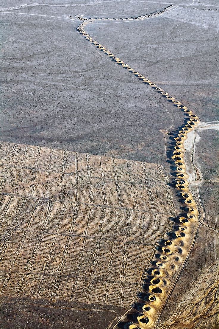
The primary locations housing these complex hydraulic networks are situated across the arid sloping piedmonts, alluvial fans, and desert valleys where access to surface water is severely limited by climatic conditions. These significant archaeological features are characteristically identified through advanced aerial surveys, satellite imagery analysis—such as CORONA and high-resolution spaceborne platforms—and systematic surface pedestrian surveys. Discovered as long linear chains of circular depressions winding across desert plains, these systems preserve their exact spatial relationships with ancient agricultural fields, terraced farms, and desert settlements. This secure landscape placement confirms that the networks were engineered as permanent regional infrastructure rather than isolated artifacts, serving as primary indicators of ancient water distribution and demographic expansion.
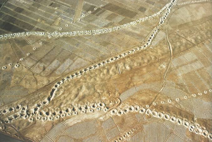
The materials utilized in constructing these subterranean works consist predominantly of local geological strata, including compacted alluvial soils, gravel matrices, and quaternary sediment deposits through which the tunnels are hand-dug. The manufacturing techniques visible under close archaeological inspection reveal that ancient engineers excavated a series of vertical access shafts—frequently spaced between 20 to 100 meters apart—interconnected by a gently sloping underground gallery designed to transport water via gravity without mechanical pumps. The spoil excavated from each vertical shaft was deposited around the rim, creating the characteristic rings of earth visible from the air that trace the path of the hidden water channel. These physical production traits reflect an advanced mastery of surveying, subsurface geometry, and cooperative labor organization, allowing ancient societies to harness deep aquifers safely.
The functional significance and ultimate utility of these monumental water systems are deeply tied to sustainable irrigation, municipal drinking supply, desert survival, and the prevention of regional soil salinization. In these hyper-arid environments, the subterranean channels successfully transported fresh mountain groundwater over long distances while minimizing loss from evaporation and extreme heat. Furthermore, the alignment of access wells and ᴀssociated grid-like field patterns suggests complex structural arrangements designed for regular maintenance, sediment clearance, and controlled agricultural distribution. Beyond their immediate economic utility, these hydraulic landscapes embody a unique intersection of ancient resource management, ecological resilience, and monumental public engineering.
The scientific documentation, aerial mapping, and ongoing heritage preservation of these archaeological landscapes are the result of collaborative fieldwork conducted by international archaeologists, geomorphologists, and remote-sensing specialists. The systematic identification and documentation of thousands of qanat and karez lines have been advanced through decades of regional archaeological surveys, historical text analysis, and modern geospatial modeling utilizing satellite archives. Modern research teams continue to employ digital elevation models and automated feature-detection algorithms to monitor landscape modifications and safeguard these fragile historical waterscapes from modern agricultural encroachment. Through these rigorous scientific frameworks, researchers strive to preserve the physical legacy of ancient hydro-technology while deepening our understanding of human adaptation to arid environments across time.
✓ hoangduc
The scientific documentation and archaeological study of extraordinary ancient hydraulic landscapes, such as the expansive subterranean qanat systems, represent a crucial avenue of research into ancient civil…